When it comes to exploring a new place or navigating from one city to another, Google Maps is perhaps one of the best navigation apps to do it. Available for iOS, Android, and the web, this navigation app makes navigation easy and stress-free. However, to get the most out of Google Maps, it's essential that you know everything about this app, whether you're on your phone or on the web.
Contents1. Add your music app2. Search and navigate under the radar3. See the interior maps of museums and monuments4. Add a temporary parking space5. Add custom labels and shortcuts6 Create custom maps7. Voice search8. Check the elevation of the road9. Check the crowd10. Pin your favorite places11. View your data and automatically delete location historySmart Route
Hence, we have taken the initiative to list down some of the essential Google Maps tips and tricks to help you get the most out of this app.
Since this is going to be a long post, let's get to it, okay?
Road trips and music are the ultimate combinations. However, unless you're using the car's built-in navigation system, switching between the music app and Maps can be tricky. The good news is that you can now control your music playback directly through Maps. Undoubtedly, this feature comes in handy if you control music and navigation from your smartphone.
For now, Maps for Android supports Spotify and YouTube Music (among others), while iPhones support Apple Music and Spotify.
To add a music app to Maps, go to Settings> Navigation Settings and select Default Media Provider (for Android) or Music Controls (for iPhone). Then select the application from the list according to your preference.


The next time you start a journey, music controls will be available at the bottom.

Android users will need to enable Driving View (Settings> Navigation> Google Assistant Settings) to see the playback controls at the bottom.
You may already know that Google Maps saves most of your searches and the places you've visited. If allowed, the app also places these searches and trips on your calendar. However, if you want to fly under the radar, Incognito mode is the one you should try.
This mode hides your location searches or shared location. The good thing is that it is quite easy to turn it on.
The next time you don't want a search to appear on your timeline, tap the profile icon in the top-right corner and select the Enable incognito mode option.

After that, you can disable it in the same way.
When browsing in incognito mode, you won't see your saved places and pinned locations.
Do you want to see inside the Plaza Mayor of Madrid through maps? Simple. Find the location on your phone's maps and select Street View by tapping the layer icon in the top right corner.


This will highlight visible areas in blue. Tap one of the many lines to virtually "travel".
The same option is also available in the web version.
One of the cool features of Google Maps is the Add Parking feature. Using it, you can quickly save where you parked your car/bike. Once you've marked a parking spot, you can easily return to it.
In addition to saving your parking location, you can also use this feature to temporarily save landmarks, especially when exploring a new location or city. In our case, we used this feature to save the locations of cute little shops and cafes that aren't on Google Maps to visit later in the day/evening.

To add a parking spot, tap the little blue dot menu and tap the Set as parking spot option.
For a very long time, Maps had the ability to add your home and work locations. Once added, you can easily navigate to these locations with a single click. Now the iOS and Android apps for Google Maps let you add custom labels for quick navigation. These labels can either be those of the restaurants you usually go to or your friend's.
To add them, tap the search box on your mobile app and tap More. Next, tap the little More button in the lower right corner.
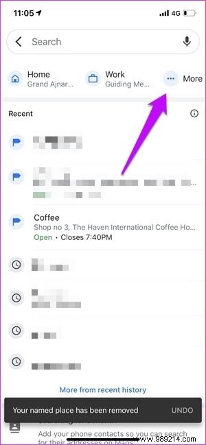

Next, search for the location, then press the OK button to add the location.

Once added, you can find these labels next to Work and Home. Cool, right?
Did you know that Google Maps for the web lets you create custom maps? Using this you can add your locations, routes, shapes and hiking trails. For example, if you are planning a route, you can use the custom maps to mark the places of your visit. The best part is that you can keep these cards private.
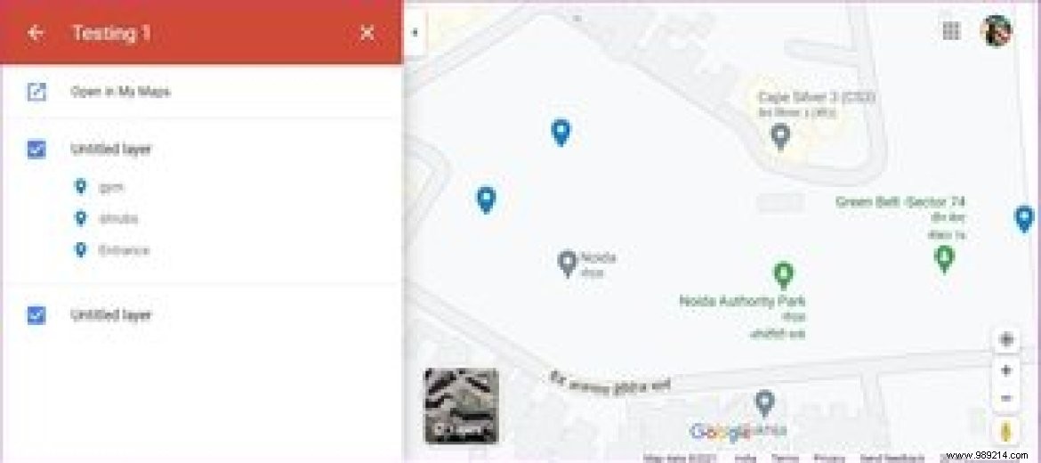
Although this option is available for Android, the web version is much easier to use. However, you may find it a bit complicated at first.
Once you've created the map, it will be available under Your Places> Maps.
Maps for iOS does not support this feature.
If you don't want to take your eyes off the roads while driving, you can use Google Assistant voice search to find locations, ask for directions and other details.
Android users can say "Ok, Google" followed by the command. On the other hand, iOS users will need to enable this setting. One downside for iPhone users is that you cannot use Siri for voice commands while navigating.
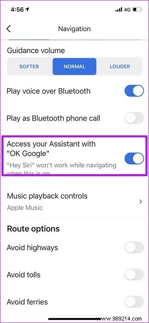
To do this, go to Settings> Navigation and enable the "Access your assistant..." option as shown above.
Did you know that Google Maps also lets you see road elevations? This helps you plan your runs and walks, especially if you're new to an area.
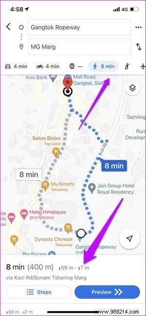

To do this, find the place on Maps and switch to walking mode. The altitude will be displayed alongside the time and distance. Now tap on it to see the full elevation detail.
It's 2021 and the world is still in the grip of the COVID-19 pandemic. At times like these, you'll want to avoid crowded places. If you are unsure of a public place, you can check the times when the place is busiest to plan your visits accordingly.

Find the location in your phone and swipe up on the details map. Scroll down until you see the Popular Calendars section.
Here you will see a graph detailing the overcrowding of the place, and based on this you can plan your visit as such.
Did you know that Maps lets you pin some of your favorite places and routes? If you go to your favorite Taco restaurant almost every Friday, you can check traffic details or the shortest route before you hit the pedal.
If you search for the place often enough, chances are it will be visible under the Go tab. Once you locate it, all you have to do is tap the Pin icon.

The next time you need to see traffic, head to the Go tab and tap on pinned locations to begin your journey. Simple, see. And hey, you can pin multiple places at once.
If you don't see the place/location under the Go by chance tab, you may need to add the place to your list of saved tags (see #6).
This feature is available on iOS and Android.
As mentioned earlier, Google logs most of your searches and browsing. This helps personalize your Maps experience as the app tailors suggestions to suit your tastes. At the same time, you can also use this feature to revisit all the places you visited in the past.
However, if you are not comfortable with this, you can turn off Location History. On your iPhone or Android phone, tap your profile in the top right corner and select Your Data in Maps.

You'll see all the data saved by Maps, including recent searches and reviews. To delete your location history, tap Location History and choose an automatic deletion option.
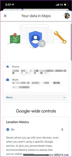

For now, the app gives you three options:3 months, 18 months or 36 months.
Perhaps two of the most important features of Google Maps are adding multiple stops or finding gas and restaurants along the way. The best part is that most of them are available on iOS and Android.
So which of these Google Maps features do you use the most?